F249 to Þórsmörk
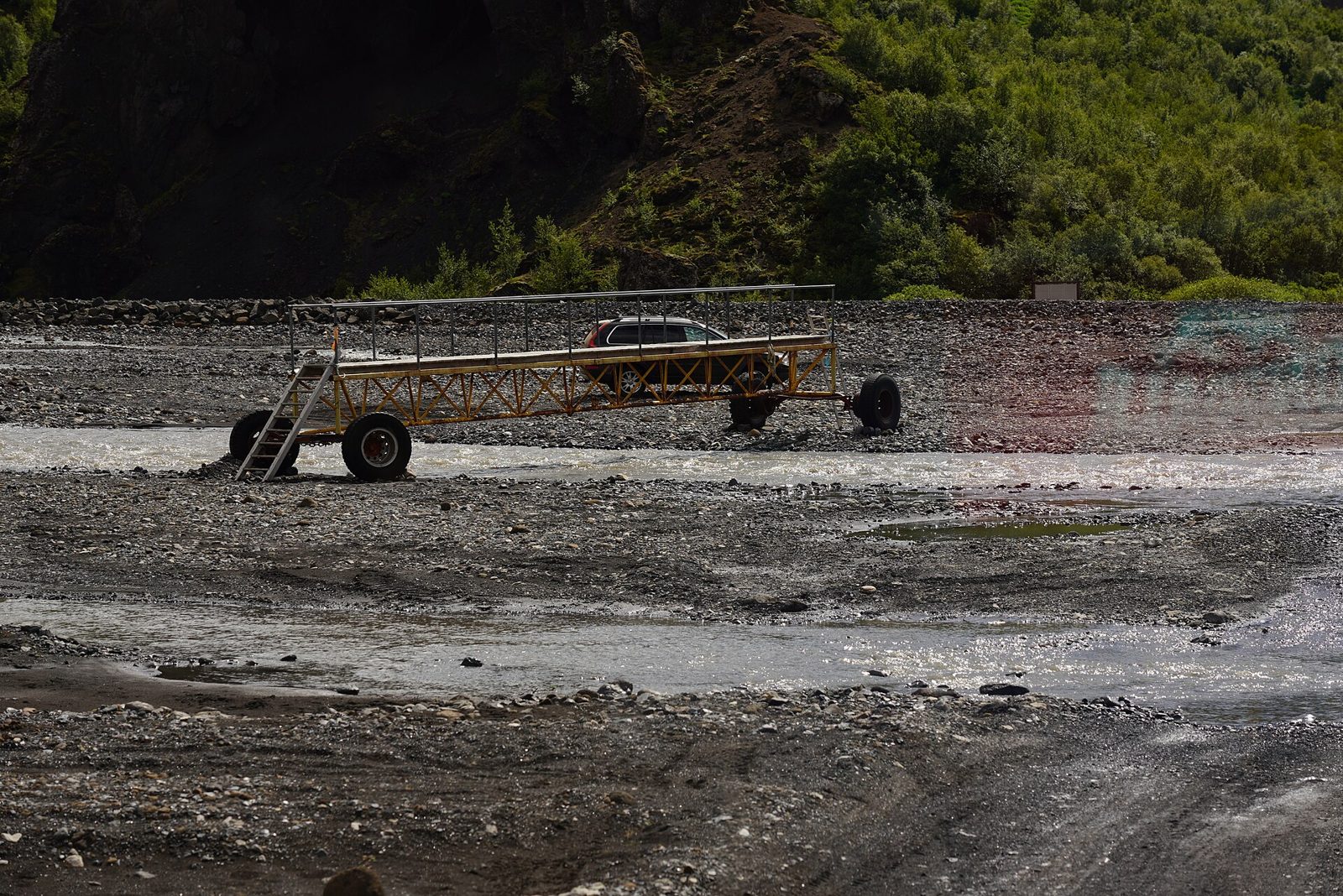
F249, Þórsmerkurvegur, is the only road into the Þórsmörk valley - and Iceland's most notorious F-road for drowned cars. The road surface itself is easy; the trap is the rivers, which start as puddles near the Ring Road and end at Krossá, one of the largest unbridged fords on any marked road in Iceland. Most rental agreements ban this road outright. Here is how the route actually works, and how to visit Þórsmörk without risking a car.
The Route And Its Rivers
The drive leaves the Ring Road by Seljalandsfoss on road 249, whose tarmac ends shortly after the waterfall; it continues as ordinary gravel - still open to normal cars - before becoming F249 after roughly 10 km. Básar lies about 31 km from the junction, 1.5–2 hours of slow driving. The fords escalate as you go: a fast, murky crossing near the Lónið lagoon, then Steinsholtsá - a medium-to-large glacial river with a record of sinking rental cars - followed by Stakkholtsgjá and Hvanná before the valley proper. This gradual build-up is exactly what catches drivers out: the road looks harmless for the first half.
Krossá: The Final Ford
Krossá, draining the glaciers around the valley, is the last and by far the biggest crossing. Its gravel bed shifts daily, its depth is unpredictable, and there is no fixed safe line - buses cross it at an angle, feeling their way, and even purpose-built super jeeps and the scheduled highland bus have been stuck in it. No rental insurance covers water damage anywhere in Iceland, and on this river even experienced local drivers routinely choose not to cross. Treat Krossá as super-jeep territory with no guarantees.
You Don't Need To Cross It
Básar hut and the Goðaland trails are reached without crossing Krossá at all. For Langidalur campsite and the Valahnúkur viewpoint, park on the gravel before the river - well clear of the bus track - and use the summer footbridge, a walk of a few minutes. Rangers remove the footbridge when water runs too high; if it is gone, that is the river telling you the answer. Glacial melt from Eyjafjallajökull and Mýrdalsjökull means the rivers rise through warm afternoons, so what you crossed at 10 AM may be a different river at 5 PM - see our river crossing guide.
The Sensible Way In: Bus Or Tour
Because most rental contracts forbid F249 entirely, the standard way into Þórsmörk is the scheduled 4×4 highland bus from the Ring Road, or a super-jeep day tour. Both run daily in summer, cross the rivers with professional drivers in purpose-built vehicles, and drop you at the trailheads. If you drive your own capable 4×4, going as far as the Krossá parking and walking across is the proven compromise. Whatever you drive, check umferdin.is and safetravel.is the same morning - a green status confirms the road is open, not that the rivers are passable.
Worth Stopping For
Nauthúsagil, a narrow mossy ravine hiding a waterfall at its end, sits on road 249 before the F-road begins - gravel, but an ordinary road reachable by any car. Go before the crowds do. Stakkholtsgjá canyon, beyond the Steinsholtsá ford, rewards a 40-minute walk with a waterfall chamber at its finish. In the valley itself, the half-hour climb up Valahnúkur gives the definitive panorama of Þórsmörk: glaciers on three sides and braided black-sand rivers below.
Related Guides
Read the F-roads overview for where the 4×4 requirement actually comes from and insurance basics, the river crossings guide for technique, and the car rental guide for what your contract does and does not allow. For an easier taste of the highlands, compare F208 to Landmannalaugar.
Frequently Asked Questions
Can You Drive A Rental Car To Þórsmörk?
Generally no. Most Icelandic rental agreements explicitly forbid driving F249 - and because damage from driving where prohibited is excluded by every policy, no level of cover protects you there. The rivers on this road - especially Steinsholtsá and Krossá - drown more rental cars than almost anywhere in Iceland. Take the scheduled highland bus or a super-jeep tour instead; both run daily in summer from the Ring Road.
How Dangerous Is The Krossá River Crossing?
Krossá is widely considered one of the most dangerous river crossings on any marked F-road in Iceland. It is glacial, powerful and unpredictable, with a loose gravel bed that shifts daily, so there is no fixed safe line. Even 40-inch-tyre super jeeps and highland buses have been stuck in it. Most experienced drivers park before it and use the summer footbridge.
Do You Have To Cross Krossá To Visit Þórsmörk?
No. Básar hut in Goðaland is reached without crossing Krossá, and for Langidalur campsite you can park before the river and cross on a summer footbridge in a few minutes. Rangers may remove the footbridge when water is too high, in which case the highland bus is the only sensible way across. The best of Þórsmörk is walkable from either side.
When Is F249 Open?
F249 typically opens in late May or early June - earlier than most F-roads, since it starts near sea level - and closes around September. Opening is only half the story: high water can make the road effectively impassable even when its status is green, because road status does not report river depth. Check umferdin.is and ask locally on the day.
What Can You See Along F249 Without A Super Jeep?
A surprising amount. Nauthúsagil ravine and its hidden waterfall lie on road 249 - gravel by that point, but an ordinary road passable by any car, since the tarmac ends shortly after Seljalandsfoss. Stakkholtsgjá canyon requires fording Steinsholtsá, and the classic Valahnúkur viewpoint hike starts at Langidalur. Many visitors park at the Krossá footbridge or ride the bus in and hike from there.
Sources
Checked against the Icelandic Road and Coastal Administration (Vegagerðin) and umferdin.is for road status, SafeTravel Iceland for conditions and trip registration, and Ferðafélag Íslands for hut and footbridge information. Rental-contract restrictions vary by company - always read your own agreement. River conditions change daily; confirm before travelling.
Last updated: 2026-08-02 · Reviewed against official sources.